Quiz · Medium
Measurement errors, leveling, bearings, traverse computations, contours, GNSS and earthwork.
A stream crosses contours; the contours form a V that points
downstream
upstream (uphill)
across the stream
toward the nearest road
Contours bend toward higher ground in valleys.
A contour interval of 2 m over a horizontal distance of 40 m gives a slope of
2%
5%
20%
0.05%
2/40 × 100 = 5%.
Precision in surveying measurements means
closeness to the true value
absence of blunders
the repeatability of measurements
correction for systematic error
A set of measurements can be precise but inaccurate if a systematic error shifts them all.
Which type of error accumulates in proportion to the number of measurements n?
Systematic error
Random error
Blunder
Rounding only
Systematic errors have the same sign each time so they add up as n × e. Random errors accumulate as √n.
A tape standardized at 20 °C is used at 35 °C. Compared with its nominal length, the tape is
shorter, so measured distances are too large
unchanged
longer, so measured distances are too large
longer, so measured distances are too small
Steel expands when warm; the tape covers more ground per marked length, so each reading underestimates true distance and the correction is positive.
Sag correction in taping is always
positive
negative
zero if tension is applied
equal to the tension correction
A sagging tape measures a shorter horizontal distance, so the true distance is shorter than recorded.
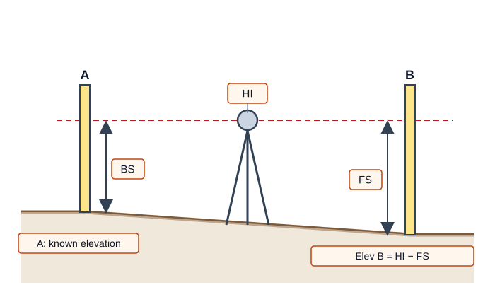
In differential leveling, the height of instrument (HI) is
elevation of a known point minus backsight
elevation of a known point plus backsight
backsight minus foresight
elevation plus foresight
HI = Elev + BS, then new elevation = HI − FS.
BM = 100.000 m, BS = 1.456 m and FS = 0.982 m. The elevation of the new point is
99.526 m
101.456 m
102.438 m
100.474 m
HI = 101.456; Elev = 101.456 − 0.982 = 100.474 m. 99.526 results from adding FS and subtracting BS.
Keeping equal backsight and foresight distances cancels mainly
collimation and curvature/refraction errors
rod graduation errors
plumbing errors
temperature errors
Equal sight lengths balance the line-of-sight error and Earth curvature.
For a closed level loop the sum of rises and falls should be
equal to the loop length
one
zero
equal to the benchmark elevation
Any nonzero value is the misclosure, to be compared with the allowable and distributed.
Which is NOT part of level circuit adjustment?
Computing the misclosure
Comparing to the allowable
Distributing correction in proportion to distance
Adjusting the horizontal angles
Angles belong in traverse adjustment.
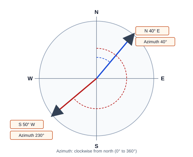
The azimuth of a line is measured
from north or south, 0° to 90°
clockwise from north, 0° to 360°
counterclockwise from east
clockwise from south
Azimuth uses north as a reference and clockwise as positive. Bearings use quadrants.
An azimuth of 130° is the bearing
N 50° E
S 40° E
S 50° E
N 130° E
130° lies in the southeast quadrant; 180° − 130° = 50° from south toward east.
The back azimuth of a line with azimuth 215° is
35°
305°
125°
395°
215° − 180° = 35°. Add or subtract 180° to stay within 0 to 360.
The sum of interior angles of a closed seven-sided polygon is
900°
720°
1,080°
1,260°
(n − 2) × 180° = 5 × 180° = 900°.
The latitude of a line of length L and azimuth Az is
L sin Az
L tan Az
L cos Az
L / cos Az
Latitude is the north-south component; departure is L sin Az.
A 100 m line with azimuth 60° has departure of
50.00 m
86.60 m
173.2 m
57.7 m
100 sin 60° = 86.60 m. 50.00 is the latitude.
The compass (Bowditch) rule distributes the closure error in proportion to
angles
latitudes only
elevations
line lengths
The correction for each line is the total error times L/P (perimeter).
Linear misclosure 0.064 m on a traverse with perimeter 800 m gives a relative precision of about
1:800
1:64
1:12,500
1:51,200
800/0.064 = 12,500.
Area of the triangle with vertices (0,0), (40,0) and (0,30) by coordinates is
600
1,200
300
70
½ × 40 × 30 = 600. 1,200 is double the area (the raw determinant).
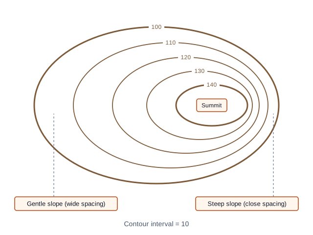
Closely spaced contour lines indicate
gentle terrain
a level surface
a depression
steep terrain
Large elevation change over a short horizontal distance.
At least how many satellites are needed for a GNSS 3D position?
3
2
6
4
Three for coordinates and one for the receiver clock bias.
Which GNSS method gives centimeter-level coordinates in real time?
RTK
Autonomous single-point
Handheld navigation
Barometric altimetry
RTK uses base corrections to resolve carrier phase ambiguities quickly.
Orthometric height H is related to ellipsoid height h and geoid height N by
H = h + N
H = N − h
H = h − N
H = h × N
A GNSS gives h; subtract the geoid separation to obtain height above the geoid.
Using average end area, a 20 m long cut with end sections 40 m² and 60 m² has volume
2,000 m³
500 m³
100 m³
1,000 m³
V = 20 × (40 + 60)/2 = 1000 m³.
