Quiz · Medium
Questions on planning history, key thinkers, zoning and legal tools, FAR, city models and street patterns.
Who proposed the garden city concept?
Ebenezer Howard
Daniel Burnham
Frederick Law Olmsted
Le Corbusier
Howard published it in 1898. Le Corbusier proposed the Radiant City, Olmsted designed parks and Burnham drew the Plan of Chicago.
Which book argued for mixed use, short blocks and 'eyes on the street'?
The Image of the City
Garden Cities of To-morrow
The Death and Life of Great American Cities
Learning from Las Vegas
Jane Jacobs published it in 1961. Lynch wrote The Image of the City.
Which are Kevin Lynch's five elements?
Zones, sectors, rings, nuclei, corridors
Paths, edges, districts, nodes, landmarks
Axes, grids, radials, loops, cul-de-sacs
Streets, blocks, plots, parks, plazas
Lynch described how people mentally map cities. The other lists mix other planning terms.
The 1926 case that upheld zoning as a valid police power was:
Kelo v. New London
Euclid v. Ambler Realty
Penn Central v. New York
Brown v. Board
Euclid established zoning. Kelo concerned eminent domain.
What is FAR for a 5,000 sq ft lot with a 15,000 sq ft total building floor area?
75
10
0.33
3.0
FAR = total floor area / lot area = 15,000 / 5,000 = 3.0. 0.33 inverts the ratio.
What does a variance do?
Grants a tax break
Permits a departure from zoning standards due to unique hardship
Changes the zoning of a whole district
Allows eminent domain
A rezoning changes the district, whereas a variance is a lot-specific exception.
Which model proposes growth in wedges along transport routes?
Christaller's central place theory
Burgess's concentric zone model
Harris and Ullman's multiple nuclei model
Hoyt's sector model
Hoyt (1939) saw land uses radiating along transport lines. Burgess used rings.
What is a key feature of New Urbanism?
Walkable, mixed-use neighborhoods with varied housing
Cul-de-sac supersizing
Single-use zoning with large lots
Elimination of public transit
It reacts against sprawl. The other options describe conventional suburban development.
What is a transit-oriented development?
A highway interchange with big box stores
Compact mixed-use development around a transit station
A single-family subdivision with a bus stop
A parking-only district
TODs encourage walking and ridership. A bus stop alone does not make a TOD.
Which city is known for its urban growth boundary established in the 1970s?
Houston, Texas
Portland, Oregon
Atlanta, Georgia
Phoenix, Arizona
Oregon's land-use laws led to Portland's UGB. Houston is famous for having no conventional zoning.
In Arnstein's ladder, which rung is 'citizen control'?
It is not on the ladder
The top rung, in the citizen power group
The bottom rung, nonparticipation
A middle rung, tokenism
The ladder runs from manipulation at the bottom to citizen control at the top.
Who designed the Plano Piloto of Brasília?
Le Corbusier
Lúcio Costa
Pierre L'Enfant
Walter Burley Griffin
Costa won the 1957 competition; Niemeyer designed the buildings. Griffin planned Canberra and L'Enfant Washington.
Which feature defines a complete street?
It has a minimum of six lanes
It accommodates all users: pedestrians, cyclists, transit and drivers
It is fully pedestrianized
It has no parking
Complete streets balance multiple modes; they are not only for cars or only for pedestrians.
What is induced demand?
Rising rents due to new transit
Demand for housing from job growth
More road capacity attracts more traffic, so congestion returns
Demand for transit created by free fares
Studies show added lanes fill up. The other options describe different phenomena.
In Burgess's model, zone 2 is the:
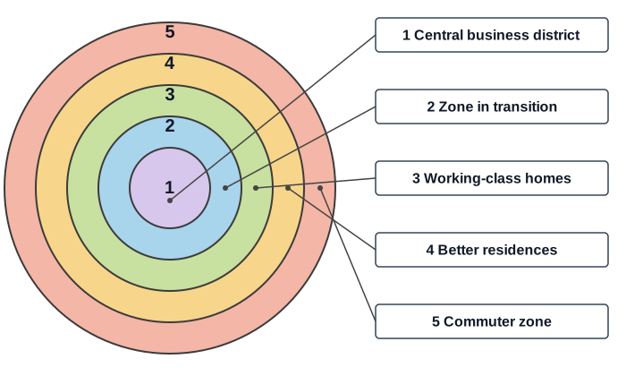
Working-class zone
Central business district
Commuter zone
Zone in transition
Zone 2 had deteriorating housing and industry bordering the CBD. The commuter zone is the outermost ring, zone 5.
The street pattern in the right panel (dead-end streets with turnarounds) is called:
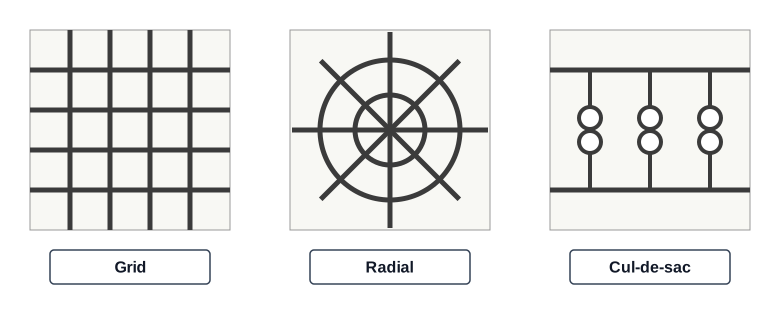
Cardinal
Cul-de-sac
Grid
Radial
Cul-de-sacs reduce through traffic but limit connectivity.
Which model is the third panel, with several separate centers?
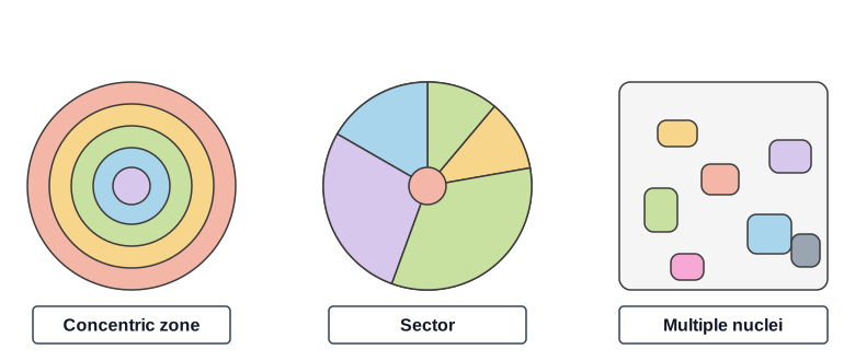
Central place model
Multiple nuclei model
Sector model
Concentric zone model
Harris and Ullman (1945) described cities with several nuclei. Hoyt's sector model has wedges.
Radburn, New Jersey, separated pedestrians and cars using superblocks and path networks.
True
False
It was designed in 1929 as a 'town for the motor age'.
Inclusionary zoning prohibits any affordable housing in new projects.
True
False
It requires or encourages affordable units in new developments.
Haussmann's renovation of Paris took place in the 1850s and 1860s under Napoleon III.
True
False
He served as prefect of the Seine from 1853 to 1870.
Which statement about eminent domain is correct?
Government may take land without any compensation
Only federal government may use it
It only applies to roads
Government may take private property for public use with just compensation
The Fifth Amendment requires just compensation. State and local governments also use it.
A rural-to-urban scale used in form-based codes is called the:
Zoning ladder
Gradient index
Transect
Density curve
The SmartCode transect runs from T1 to T6.
What housing cost share is the usual US affordability threshold?
50%
15%
10%
30% of household income
HUD defines households paying over 30% as cost-burdened.
