Quiz · Hard
Exam-style questions on the evidence for plate tectonics, boundary types, seismic waves, magnitude calculations and tsunamis.
Wegener's continental drift hypothesis was initially rejected mainly because:
Fossil evidence contradicted it
He could not explain a mechanism strong enough to move continents
No two coastlines fit together
Seafloor maps showed ridges were older than the continents
His evidence (coastline fit, fossils, rocks, glacial deposits) was strong, but his proposed forces (tides, Earth's rotation) were far too weak. A convincing mechanism came with seafloor spreading in the 1960s.
Fossils of Glossopteris occur in South America, Africa, India, Australia and Antarctica. This most strongly suggests that:
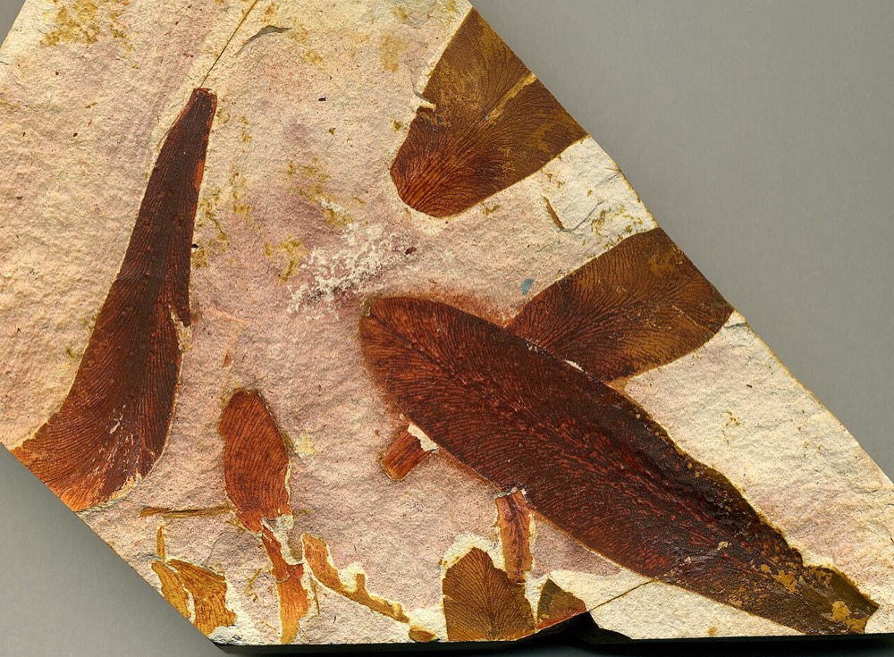
These landmasses were once joined
The plant had winged seeds that crossed the oceans
All continents have the same climate today
Sea level was once much lower
Glossopteris had heavy seeds that could not cross wide oceans, so the continents were connected as Gondwana.
Image: James St. John, CC BY 2.0, via Wikimedia Commons.
The seafloor magnetic anomaly pattern shown is symmetrical on both sides of a ridge. This is evidence for:
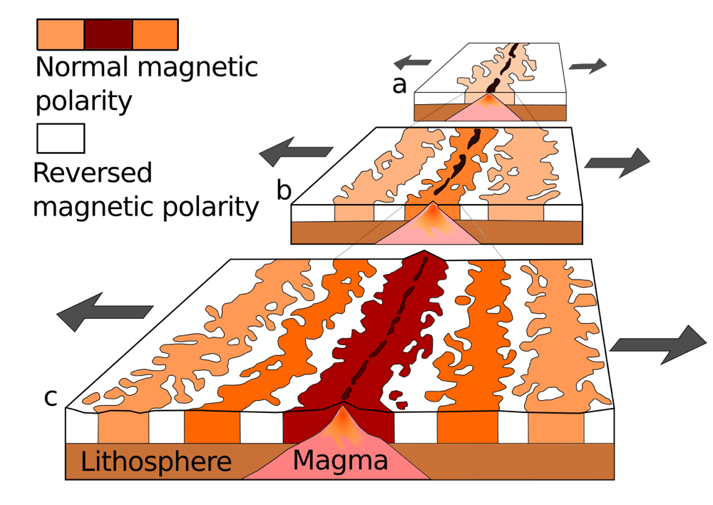
Plate collision
Mantle plumes under the ridge
Continental crust beneath the ocean
Seafloor spreading with periodic magnetic reversals
New crust forms at the ridge and records the field direction at the time, then splits and moves away on each side, creating mirror-image stripes.
Image: Chmee2, Public domain, via Wikimedia Commons.
Oceanic crust is no older than about 180-200 million years, while continental crust can exceed 4 billion years. Why?
Oceanic crust is eroded away by waves
Oceanic crust never forms from magma
Oceanic crust is recycled into the mantle at subduction zones
Earth's oceans are only 200 million years old
Dense oceanic lithosphere sinks at trenches. Buoyant continental crust is not subducted, so it survives much longer.
Which is generally considered the most important force driving plate motion?
Ridge push
Slab pull
Tides
Earth's rotation
Dense subducting slabs pull the rest of the plate with them. Ridge push is smaller; tidal forces and rotation are negligible.
A new ocean basin is beginning to form in a continental area where the crust is being stretched, with volcanoes and a long valley. Which is the best example?
East African Rift
The Himalayas
The San Andreas Fault
The Andes
The East African Rift is an active continental rift (divergent boundary). The Himalayas are a collision zone, the San Andreas is a transform fault, and the Andes are above a subduction zone.
In the subduction-zone diagram, which feature marks the line where the descending plate bends and sinks?
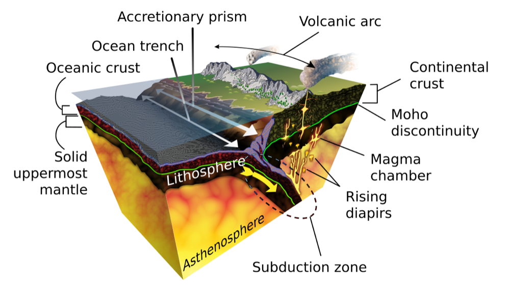
A rift valley
A volcanic island
A mid-ocean ridge
An ocean trench
A trench marks where the subducting plate bends down. Mid-ocean ridges and rift valleys form at divergent boundaries.
Image: KDS4444, CC BY-SA 4.0, via Wikimedia Commons.
Which statement about convergent boundaries is correct?
Oceanic-oceanic convergence creates mid-ocean ridges
Ocean-continent convergence never produces volcanoes
Continental-continental collisions produce high mountain ranges, because neither plate subducts easily
Continental crust is denser than oceanic crust
Both continental plates are buoyant, so they crumple and thicken. Subduction at an ocean-ocean or ocean-continent boundary produces volcanic arcs.
The Wadati-Benioff zone is:
A transform fault in the Pacific
A dipping zone of earthquakes along a subducting slab, down to about 700 km
The boundary between crust and mantle
A line of hotspots
It marks the cold, brittle slab sinking into the mantle. Earthquakes there can be deep-focus (300 to 700 km), found nowhere else.
The Hawaiian Islands lie in the middle of the Pacific plate. Which explains their volcanism?
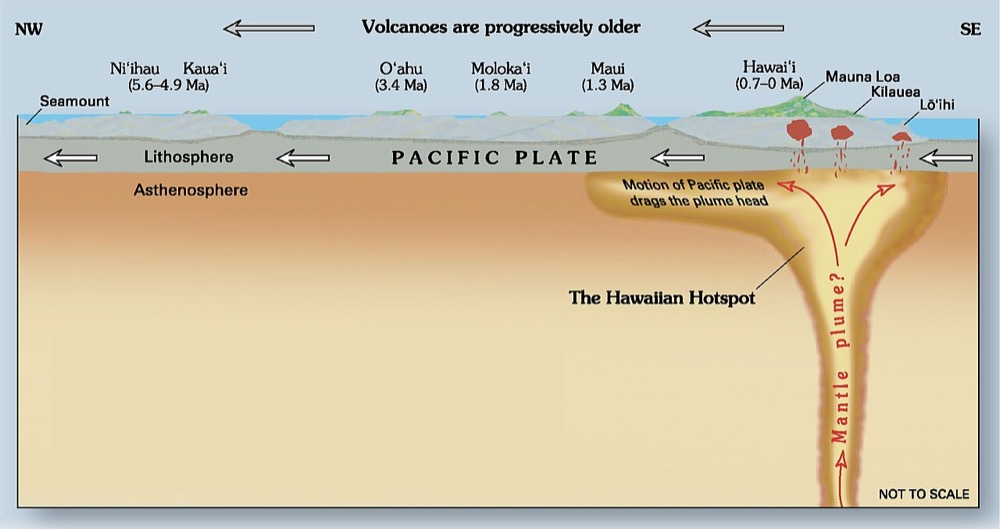
A mantle plume (hotspot) beneath the plate
A divergent boundary beneath the islands
A subduction zone beneath Hawaii
A transform fault beneath the islands
The Pacific plate moves over a relatively fixed hotspot, building a chain of volcanoes that get older to the northwest.
Image: Joel E. Robinson, USGS., Public domain, via Wikimedia Commons.
The photograph shows a linear valley with offset streams in California. Which boundary type and sense of motion does this fault have?
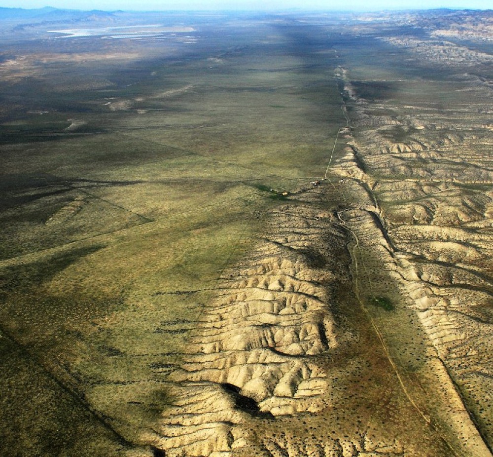
Divergent, normal
Convergent, reverse
Transform, left-lateral
Transform, right-lateral
The San Andreas Fault separates the Pacific plate from the North American plate; the Pacific side moves northwest relative to the North American side, which is right-lateral motion.
Image: John Wiley User:Jw4nvc - Santa Barbara, California, CC BY 3.0, via Wikimedia Commons.
P waves can travel through all of Earth's layers, but S waves cannot pass through the outer core because:
S waves travel too fast
S waves are compressional
S waves cannot travel through liquids
The outer core is solid
S waves are shear waves and require rigidity. Their disappearance beyond 104 degrees showed that the outer core is liquid.
Seismograph A records an S-P interval of 20 seconds and seismograph B records 55 seconds. Which is true?
The earthquake was closer to B
The earthquake was closer to A
A recorded a larger magnitude
The earthquake was equidistant
The S-P interval increases with distance because S waves fall further behind P waves. Magnitude cannot be found from the interval alone.
A magnitude 8.0 earthquake releases about how many times more energy than a magnitude 6.0 earthquake?
About 1,000
About 100
About 2
About 10
Energy ratio = 10^(1.5 × 2) = 10³ = 1,000. A factor of 100 is the amplitude ratio.
What does the Modified Mercalli scale measure?
The energy released at the focus
The depth of the focus
The speed of P waves
The intensity of shaking and damage at a place
Mercalli is an observational intensity scale (I-XII) that varies with distance and local ground. Magnitude is a single value for the earthquake's size.
Why is the surface wave the most damaging type?
It travels fastest
It travels through the core
It has the largest amplitude and strongest shaking near the surface
It is the first to arrive
Surface waves arrive last but have the largest amplitude and longest duration. P waves are fastest but weaker.
A tsunami traveling across the open ocean at a depth of 4,000 m moves at roughly:
70 km/h
700 km/h
7,000 km/h
7 km/h
v = sqrt(9.8 × 4000) ≈ 198 m/s ≈ 710 km/h. In deep ocean they are fast but very low in height.
What usually happens to tsunami speed and height as it reaches shallow coastal water?
Speed decreases and height increases
Both decrease
Both increase
Speed increases and height decreases
Wave speed depends on water depth. As the front slows, the wave behind it bunches up, so height (amplitude) grows.
Why are explosive volcanoes common above subduction zones but rare at mid-ocean ridges?
Ridges are too cold to produce magma
Mid-ocean ridges are on land
Subduction zones lack water
Subduction releases water that creates viscous, gas-rich andesitic magma, while ridge magma is basaltic and runny
Water from the slab lowers the melting temperature of the mantle wedge and the resulting magma is silica-rich and gas-rich. Ridge basalt is fluid and effusive.
Which of the following is evidence that the seafloor is spreading?
Ocean crust is older than continental crust
Rocks at the ridge are the oldest on the seafloor
Sediment thickness and rock age increase with distance from the ridge
Mid-ocean ridges lack earthquakes
Samples from deep-sea drilling show the youngest rocks and thinnest sediments at the ridge crest, with age and sediment thickness increasing away from the ridge.
In the seafloor-age map, which color band lies along the mid-ocean ridges?
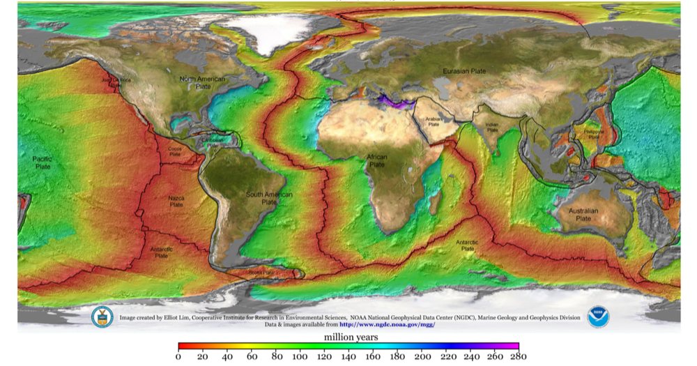
The oldest crust (purple)
The youngest crust (0 Ma, red)
Middle-aged crust (green)
There is no age variation
New crust forms at the ridges so they are the youngest. Oldest crust appears in the far western Pacific and parts of the Atlantic margins.
Image: Elliot Lim, CIRES & NOAA/NGDC, Public domain, via Wikimedia Commons.
The Cascadia subduction zone threatens the US Pacific Northwest with a possible earthquake and tsunami. The subducting plate is the:
Juan de Fuca plate
Pacific plate
Nazca plate
Cocos plate
The small Juan de Fuca plate sinks beneath North America at Cascadia. The Nazca plate subducts beneath South America, and the Cocos plate beneath Central America.
True or false: The Himalayas are an example of an ocean-continent convergent boundary with a volcanic arc.
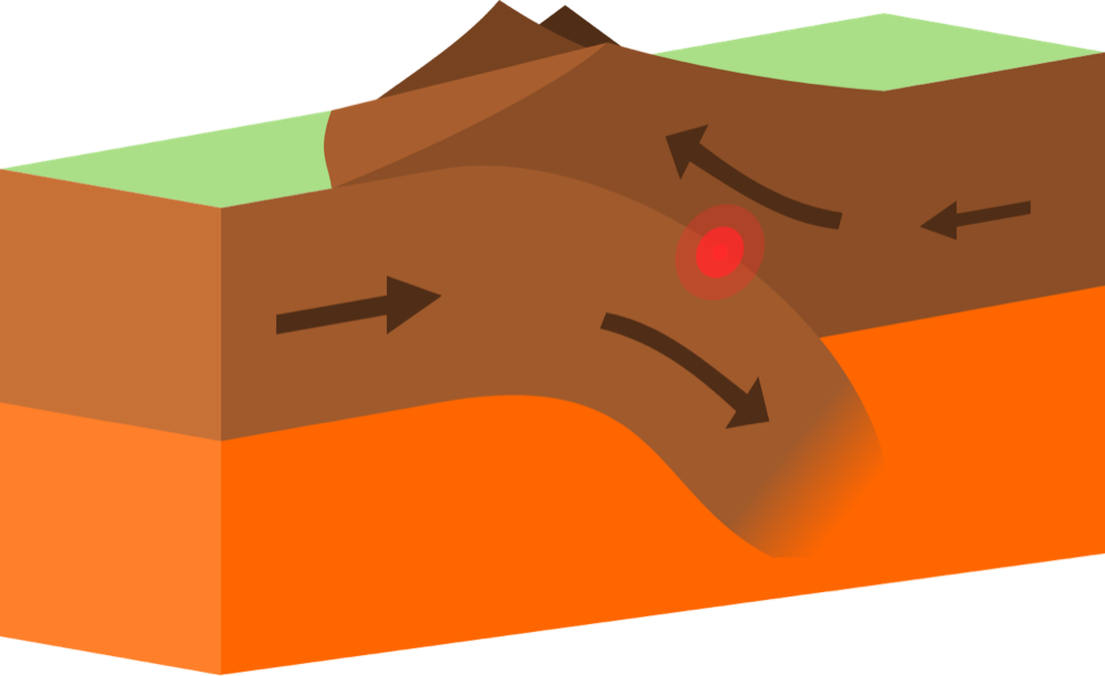
True
False
The Himalayas formed by continent-continent collision between India and Eurasia, with no volcanic arc. Ocean-continent convergence produces arcs such as the Andes.
Image: domdomegg, CC BY 4.0, via Wikimedia Commons.
