Quiz · Medium
Questions on seafloor features, seawater properties, ocean zones, currents and upwelling, waves, tides and ENSO, with image and calculation questions.
Which is the correct order of seafloor features moving from the coast out to the deep ocean (off a passive margin)?
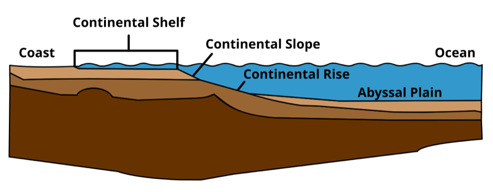
Continental slope, shelf, abyssal plain, rise
Continental shelf, slope, rise, abyssal plain
Abyssal plain, rise, slope, shelf
Continental shelf, rise, slope, abyssal plain
The shelf is the gently sloping edge of the continent, the slope is a steep drop, the rise is a sediment apron at its base, and the abyssal plain is the flat deep seafloor.
Image: Original: Interiot Vector: Pduive23, Public domain, via Wikimedia Commons.
Where is the deepest part of the ocean found?
In an oceanic trench at a subduction zone
On the crest of a mid-ocean ridge
On the continental shelf
On the abyssal plain
Trenches such as the Mariana Trench form where one plate sinks beneath another and reach about 11 km. Ridges are shallow because the crust is young and hot.
Which of the following best describes the effect of ocean acidification?
Seawater becomes more basic
Salinity falls
Seawater pH decreases, making it harder for shell-forming organisms to form calcium carbonate
Sea level rises
CO₂ dissolves in seawater, forming carbonic acid, which reduces carbonate ion concentration needed for shells and corals.
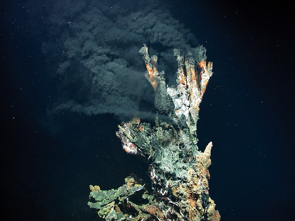
Black smokers on mid-ocean ridges support ecosystems based on:
Photosynthesis
Sunlight reaching the seafloor
Decaying plankton falling from the surface
Chemosynthesis
There is no sunlight at these depths. Microbes oxidize sulfide to obtain energy and supply the food web. Photosynthesis needs light.
Image: MARUM − Zentrum für Marine Umweltwissenschaften, Universität Bremen, CC BY 4.0, via Wikimedia Commons.
Which seafloor sediment type is composed of the shells of microscopic organisms?
Terrigenous sediment
Hydrogenous nodules
Biogenous ooze
Cosmogenous dust
Ooze consists of foraminifera, coccolithophores, diatoms and radiolarians. Terrigenous sediments come from land; hydrogenous sediments precipitate from seawater.
A sonar pulse takes 8.0 seconds to return from the seafloor. If sound travels at 1,500 m/s, how deep is the water?
12,000 m
6,000 m
3,000 m
1,500 m
Depth = (speed × round-trip time) ÷ 2 = 1,500 × 8.0 ÷ 2 = 6,000 m. Forgetting to divide by two gives 12,000 m.
In the open subtropical ocean, where is surface salinity highest?
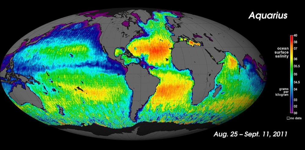
Where evaporation exceeds precipitation, in the subtropical gyres
At the equator
Near river mouths
Near the poles where ice melts
Dry, sinking air at about 25-30° latitude drives strong evaporation. Heavy tropical rain, rivers and melting ice dilute surface water.
Image: NASA/GSFC/JPL-Caltech, Public domain, via Wikimedia Commons.
What is the thermocline?
The warm surface layer
The boundary between two currents
The deepest part of the ocean
A layer in which temperature drops rapidly with depth
Beneath the mixed surface layer, temperature decreases quickly across the thermocline to the cold deep water.
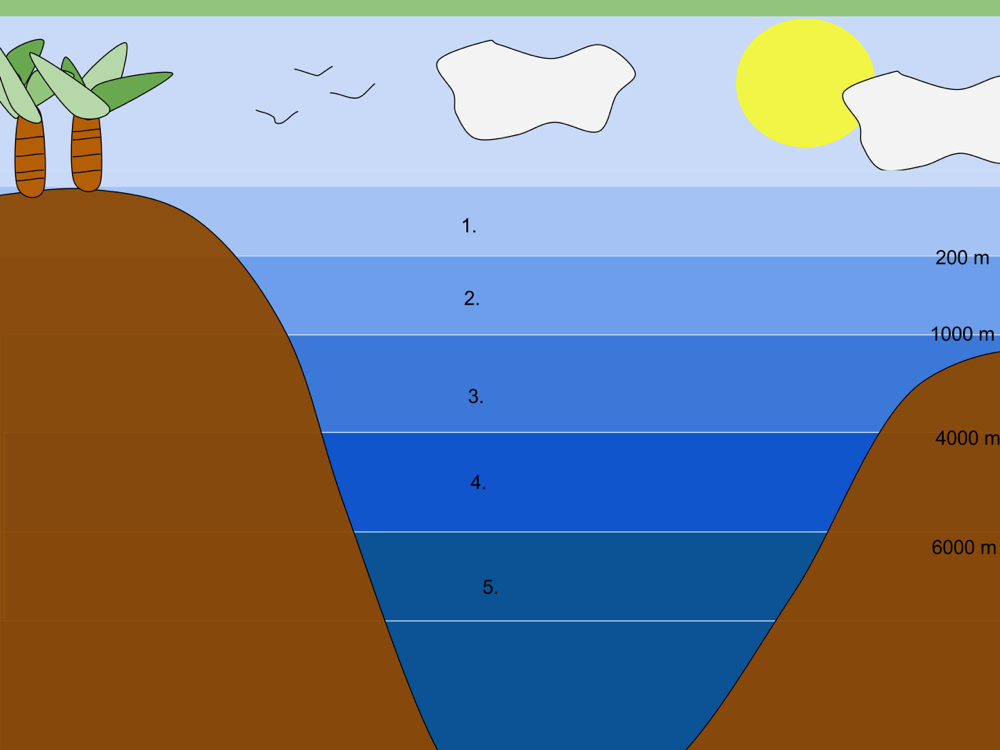
Which zone of the ocean is known as the 'twilight zone', receiving some light but too little for photosynthesis?
Epipelagic zone
Bathypelagic zone
Mesopelagic zone (200-1,000 m)
Hadal zone
Epipelagic is the sunlit zone with photosynthesis, bathypelagic is dark. The mesopelagic is dim.
Image: Awakening Conscience, CC BY-SA 4.0, via Wikimedia Commons.
About what fraction of an iceberg's volume is below the waterline?
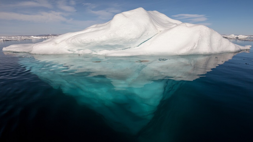
About 10%
About 90%
About 50%
About 25%
Glacial ice is only slightly less dense than seawater, so only about a tenth shows above the surface.
Image: AWeith, CC BY-SA 4.0, via Wikimedia Commons.
Which statement about the Northern Hemisphere subtropical gyres is correct?
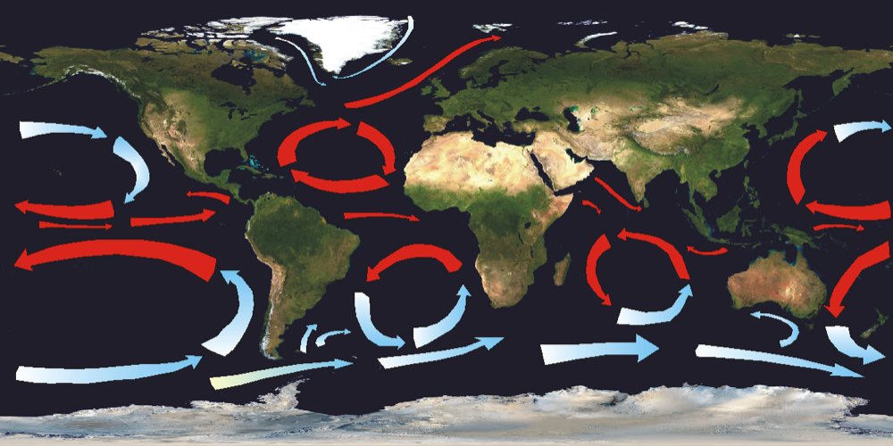
They rotate clockwise
They rotate counterclockwise
They do not rotate
They alternate each season
Winds and Coriolis deflection push water to the right, making clockwise gyres in the Northern Hemisphere (counterclockwise in the Southern Hemisphere).
Image: Land_shallow_topo_2048.jpg: NASA derivative work: Ingwik (talk), CC BY-SA 3.0, via Wikimedia Commons.
Wind blows southward along the coast of California. In which direction is the net Ekman transport of surface water?
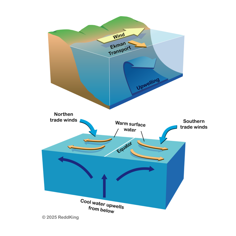
Eastward, toward the coast
Southward
Northward
Westward, away from the coast
In the Northern Hemisphere, Ekman transport is 90° to the right of the wind. For a southward wind, right means west. This causes coastal upwelling.
Image: ReddKing, CC BY 4.0, via Wikimedia Commons.
Why are western boundary currents like the Gulf Stream generally narrower and faster than eastern boundary currents?
They are driven by tides
They are caused by river discharge
Western intensification due to the variation of the Coriolis effect with latitude
Land is warmer on the west
The Coriolis force increases with latitude, which concentrates the return flow of the gyre in a narrow, swift current at the western edge.
In the thermohaline circulation, where does North Atlantic Deep Water form?
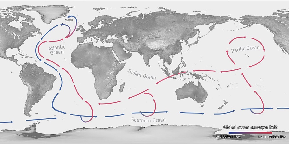
In the tropical Pacific
Near Greenland and the Labrador Sea, where cold, salty water sinks
In the Indian Ocean
In the Gulf of Mexico
Surface water cooled by polar air becomes dense and sinks. The sinking drives the global conveyor.
Image: European Space Agency, CC BY-SA 3.0 igo, via Wikimedia Commons.
What is the speed of an ocean wave with a wavelength of 90 m and a period of 10 s?
9 m/s
900 m/s
0.9 m/s
100 m/s
c = λ / T = 90 / 10 = 9 m/s.
In the wave diagram, what does the wavelength (λ) represent?
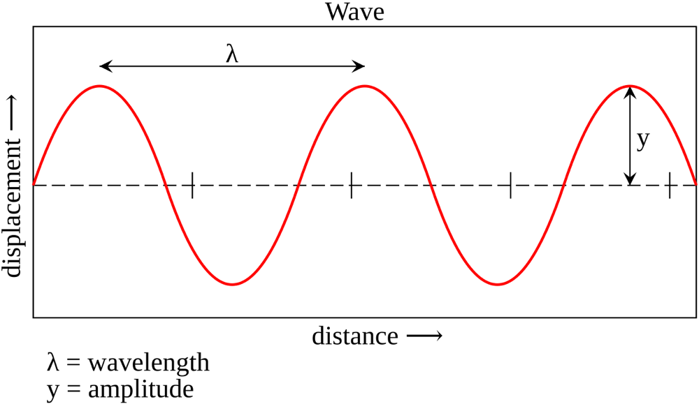
The height from trough to crest
The time for one wave to pass
The maximum displacement from still water
The distance between two successive crests
Wavelength is distance, usually between consecutive crests. Height is crest to trough, and period is time.
Image: Krishnavedala, CC0, via Wikimedia Commons.
A wave approaches the beach and its crest begins to curl and break. What explains this?
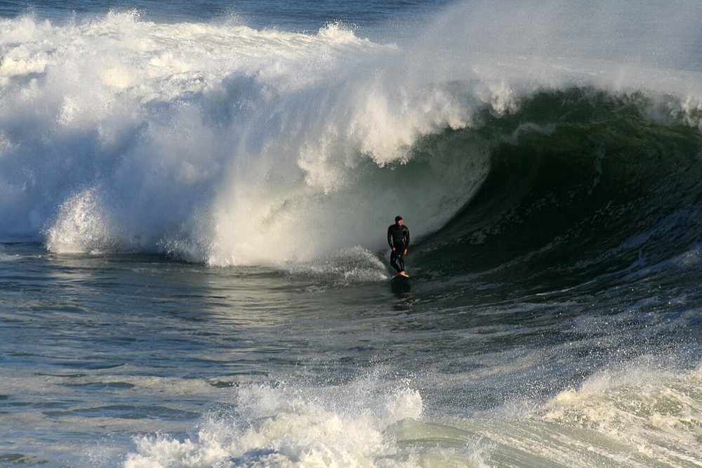
Wind speeds increase near shore
The water gets denser
The wave slows in shallow water, so the crest outruns the base and the wave steepens
The wavelength lengthens
As depth decreases, the front of the wave slows, wavelength shortens and height increases until the wave becomes unstable and breaks.
Image: Brocken Inaglory, CC BY-SA 3.0, via Wikimedia Commons.
Spring tides, with the greatest tidal range, occur when:
The Moon is at first or third quarter
The Sun, Earth and Moon are aligned (new and full Moon)
It is spring
The Moon is at its farthest point from Earth
The Sun's and Moon's pulls reinforce each other at new and full Moon. At first and third quarters they work at right angles, creating weaker neap tides.
The photograph shows a harbor in the Bay of Fundy at low tide. What causes the Bay of Fundy's enormous tidal range?
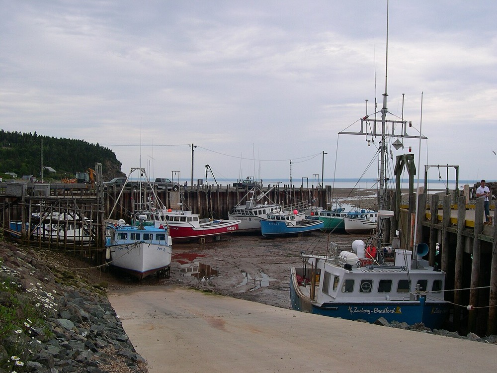
The shape of the bay amplifies the tide by resonance
The Gulf Stream
Large rivers
The Sun being closer there
The bay's length and funnel shape match the tidal period, amplifying the tidal range to about 16 m, the largest in the world.
Image: Dylan Kereluk from White Rock, Canada, CC BY 2.0, via Wikimedia Commons.
During an El Niño, which change occurs in the equatorial Pacific?
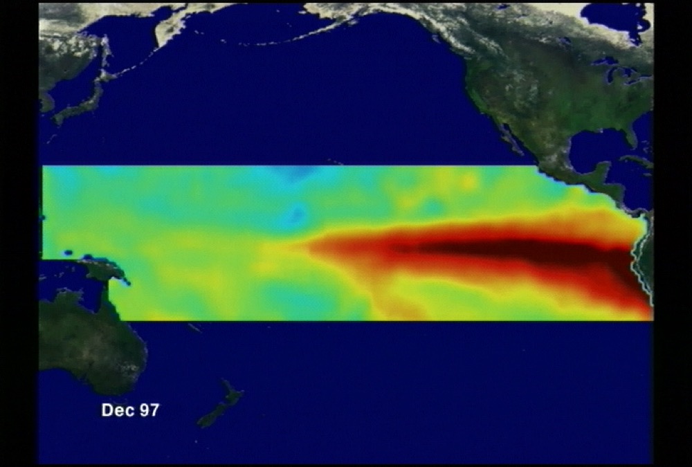
Trade winds strengthen and upwelling increases
Cold water moves westward
Rainfall increases in Indonesia
Trade winds weaken and warm water spreads eastward
Weaker trades let warm water slosh east, suppressing upwelling off Peru and shifting rainfall east, which brings drought to Indonesia and Australia.
Image: NASA's Scientific Visualization Studio - Greg Shirah, Antonio Busalacchi, Public domain, via Wikimedia Commons.
True or false: The Moon's tidal force is greater than the Sun's even though the Sun is far more massive.
False
True
Tidal force depends on mass divided by distance cubed. The Moon's proximity outweighs the Sun's mass, making it about 2.2 times as effective.
What is the main reason phytoplankton blooms occur in upwelling zones?
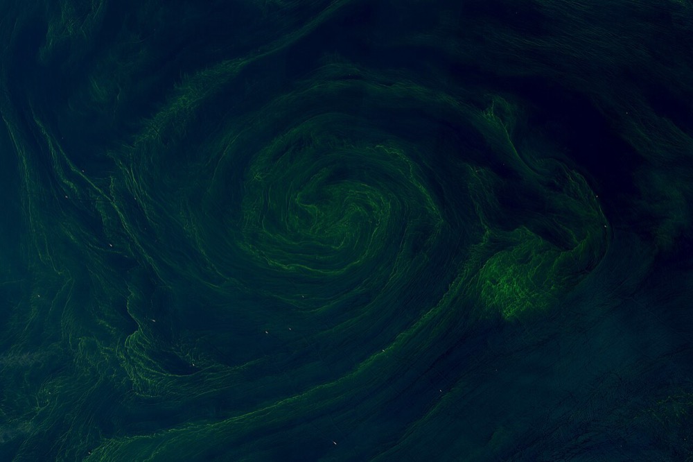
Upwelling brings nutrient-rich deep water into sunlit waters
Warm water is nutrient-rich
The water is fresher
There are no predators
Surface water is usually depleted of nutrients because organisms use them up. Upwelling restores nitrogen, phosphorus and iron to the sunlit layer, boosting productivity.
Image: NASA Earth Observatory images by Wanmei Liang, using Landsat data from the U.S. Geological Survey. Story by Adam Voiland, Public domain, via Wikimedia Commons.
